Site one!

WOOHOO! After 7 days of transit and mapping we FINALLY HAVE ARRIVED! Or more accurately we arrived last Wed. at the very base of the Emperor Seamount Chain.  This location is still known to be fished by commercial trawlers, and is one of our “human impact” sites in the search to understand how octocorals recover from disturbances. Once we got on site we started mapping to help us pick an appropriate area within the guyot to then deploy the AUV Sentry.

Sentry

AUV stands for Autonomous Underwater Vehicle, and is owned and operated by Wood’s Hole Oceanographic Institute (WHOI).  The vehicle is preprogrammed with a dive plan, then sent out into the deep blue to survey!  There are several instruments involved that keep Sentry a certain distance from the bottom and keep it from running into debris. Thus on a happily calm evening we were able to send Sentry out into the wilds.

Morgan Sunrise

Sentry deploy

We were able to keep sentry down for about 12 hours, but due to increasing wind and waves, we had to retrieve it a bit early. Unfortunately our calm period was not to last, and a pretty nasty storm is heading our way (we’re the green circle).

storm coming

Sentry was greeted by a flock of albatross (anyone knows the species give me a shout!) who were sorely disappointed by the inedibility of our catch.

albatross want sentry

I’m super stoked to check out the images Sentry brought back, and example photos look incredibly detailed, to the point to where I’m hopeful for IDing corals to genus.  The leaps in imaging technology make me so happy!

Once Sentry was onboard, we were also able to get the CTD rosette in the water before the winds made wench operations unsafe. The water crew is sampling for nutrients, chlorophyll, and radio-carbon. Fancy chemistry stuff! Maybe I can talk one of them to writing up a post about their research goals….hmmm. 🙂

Roark CTD

DSC02801

Currently we are trying to stay out of the worst of the storm and mapping another location.  30 knot sustained winds! Thankfully the Sikuliaq is capable of handling much worse conditions – just makes for a bit of a bumpy ride! Hopefully we’ll get Sentry back in the water soon!

Pacific cruise on the sikuliaq

Hi there!  After much anticipation I’m finally on board the newest ship of the University-National Oceanographic Laboratory System (UNOLS) – it’s basically and collective of university-operated ships that are available to outside researchers.  The R/V Sikuliaq is from the Seward Marine Center of the University of Alaska at Fairbanks.  I have to say I’m impressed! The vessel is 261 feet long and has 8 levels, two of which are below sea level.  It’s also an ice-breaker, but we won’t be using that feature during this cruise!

Sikuliaq

Currently we are about to enter the Papahānaumokuākea Marine National Monument (PMNM) to the west of the main Hawaiian Islands.  These small islands and seamounts were formed by the hot-spot underneath the Big Island (a.k.a. the Island of Hawai’i or Hilo) millions of years ago.  As the Pacific tectonic plate has moved, the islands are cut off from the magma source and begin to sink/erode over time.  Until recently PMNM was the largest U.S. designated sanctuary, covering ~140,000 square miles of islands and surrounding waters. A smaller, less protected version was originally dedicated in 1909, and then was broadened both in size and legal protection once in 1940, and again in 2006.

NHINM

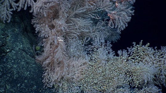
As you may have read from my “the problems with seafood” post, commercial fishing in the Pacific (outside of PMNM) consists mostly of deep-water trawling, which lands large amounts of both fish and bycatch. Of the bycatch we are most interested in the corals that would normally grow on the hard-bottomed areas below the photic zone (where sunlight can be used for plant food 😉 ) .  The corals are slow-growing, likely due to limited food resources, and they are thought to provide shelter for many other deep-sea animals.

With the increased protection of these seamounts, trawling ceased within PNMN, and we are hoping the protection has allowed the larvae of the corals from other areas to settle and repopulate the seamounts.  The larvae are directed mostly by currents to their final settling locations (imagine constantly fording the river in Oregon Trail!), but other factors like surface type, bacterial cover, and even sounds can help the larvae choose what is hopefully the best location to permanently attach and grow.

EX1404L3_IMG_20140928T164606Z_ROVHD_CORAL_CLIFF
Image credit: Okeanos

During our time at sea this year, we plan to collect some mapping data, (hopefully) determine general conditions of the water column, and take pictures and video to quantify the environment of 3 seamounts.


First step: mapping.  Better explanations of how multibeam works can be found here, but in general sound waves are sent to the sea floor and timed upon their return to get detailed information about depth and bottom quality (rough/flat, hard/soft, etc.). During our mapping we monitor the outputs and make sure the sounder is getting back adequate data.

20141120_015345

Depending on how steep the bottom is, the job is generally pretty boring. When it’s flat and consistent you basically are just babysitting to make sure data is being collected.  Over steeper areas the parameters the software is looking for to determine when it should expect sound to return have to be modified.  You generally tell it what the maximum depth should be (usually over by a few 100 m), but you don’t want to just leave it at way-over expected, because then the computer is spending too much time searching the water column.  Still, not the most exciting job (which is why it’s a great time to write this blog!).

Also, while in PMNM we have to watch for whales within 200 m of the ship and stop to make sure we don’t affect their feeding.  Depending on the density of whales there, I’m also expecting that to not be the most exciting job. Who knows though?

Humpback_stellwagen_

Once we get to Our first site we start the more involved jobs of CTD water sampling and AUV deployment. More to come!

Create a free website or blog at WordPress.com.

Up ↑