Hi there! After much anticipation I’m finally on board the newest ship of the University-National Oceanographic Laboratory System (UNOLS) – it’s basically and collective of university-operated ships that are available to outside researchers. The R/V Sikuliaq is from the Seward Marine Center of the University of Alaska at Fairbanks. I have to say I’m impressed! The vessel is 261 feet long and has 8 levels, two of which are below sea level. It’s also an ice-breaker, but we won’t be using that feature during this cruise!
Currently we are about to enter the Papahānaumokuākea Marine National Monument (PMNM) to the west of the main Hawaiian Islands. These small islands and seamounts were formed by the hot-spot underneath the Big Island (a.k.a. the Island of Hawai’i or Hilo) millions of years ago. As the Pacific tectonic plate has moved, the islands are cut off from the magma source and begin to sink/erode over time. Until recently PMNM was the largest U.S. designated sanctuary, covering ~140,000 square miles of islands and surrounding waters. A smaller, less protected version was originally dedicated in 1909, and then was broadened both in size and legal protection once in 1940, and again in 2006.
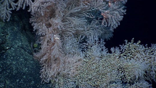
As you may have read from my “the problems with seafood” post, commercial fishing in the Pacific (outside of PMNM) consists mostly of deep-water trawling, which lands large amounts of both fish and bycatch. Of the bycatch we are most interested in the corals that would normally grow on the hard-bottomed areas below the photic zone (where sunlight can be used for plant food 😉 ) . The corals are slow-growing, likely due to limited food resources, and they are thought to provide shelter for many other deep-sea animals.
With the increased protection of these seamounts, trawling ceased within PNMN, and we are hoping the protection has allowed the larvae of the corals from other areas to settle and repopulate the seamounts. The larvae are directed mostly by currents to their final settling locations (imagine constantly fording the river in Oregon Trail!), but other factors like surface type, bacterial cover, and even sounds can help the larvae choose what is hopefully the best location to permanently attach and grow.

During our time at sea this year, we plan to collect some mapping data, (hopefully) determine general conditions of the water column, and take pictures and video to quantify the environment of 3 seamounts.
First step: mapping. Better explanations of how multibeam works can be found here, but in general sound waves are sent to the sea floor and timed upon their return to get detailed information about depth and bottom quality (rough/flat, hard/soft, etc.). During our mapping we monitor the outputs and make sure the sounder is getting back adequate data.
Depending on how steep the bottom is, the job is generally pretty boring. When it’s flat and consistent you basically are just babysitting to make sure data is being collected. Over steeper areas the parameters the software is looking for to determine when it should expect sound to return have to be modified. You generally tell it what the maximum depth should be (usually over by a few 100 m), but you don’t want to just leave it at way-over expected, because then the computer is spending too much time searching the water column. Still, not the most exciting job (which is why it’s a great time to write this blog!).
Also, while in PMNM we have to watch for whales within 200 m of the ship and stop to make sure we don’t affect their feeding. Depending on the density of whales there, I’m also expecting that to not be the most exciting job. Who knows though?
Once we get to Our first site we start the more involved jobs of CTD water sampling and AUV deployment. More to come!


I too am very interested in the work of the Sikuliaq. I photographed the launch back in 2012, followed several of the issues with trials and actually met Captain Mike and spent 2 hours in a 1 on 1 tour before the ship left the Menominee River berth on it’s maiden voyage. Mike set me up with the tracking software so I have been watching your every move since the start, on facebook. Please pass on a greeting to Mike from me when you see him.
The MPA is East of HA?
Who is writing this?
Hi Bill – oops! that’s the problem with writing while trying to get on a midnight-noon shift! I’ll fix it
…looking forward to more posts from the R/V Sikuliaq. What’s up with Ship Track…no new data for five days…
Most lat and long data for scientific sites can be proprietary until publication – mostly for publication rules about “new” work versuses previously “published.” The science crew on board currently (my cruise ended 1.5 weeks ago, I’m still catching up with family before updating the blog) is running a blog as well. You can check it out here: http://web.whoi.edu/jurassicmagnetism/ !